The Tapestry Drawing Room at Castle Howard

I was glad we opted for the House and Gardens ticket at Castle Howard, even though we’d been debating whether to or not, but it meant we could see the newly refurbished Tapestry Drawing Room. Entry to Castle Howard is expensive - and I’m sure that the upkeep and day to day running of the estate is also expensive so it’s great that they do offer a price reduction for buying your tickets in advance online, so that’s well worth doing.

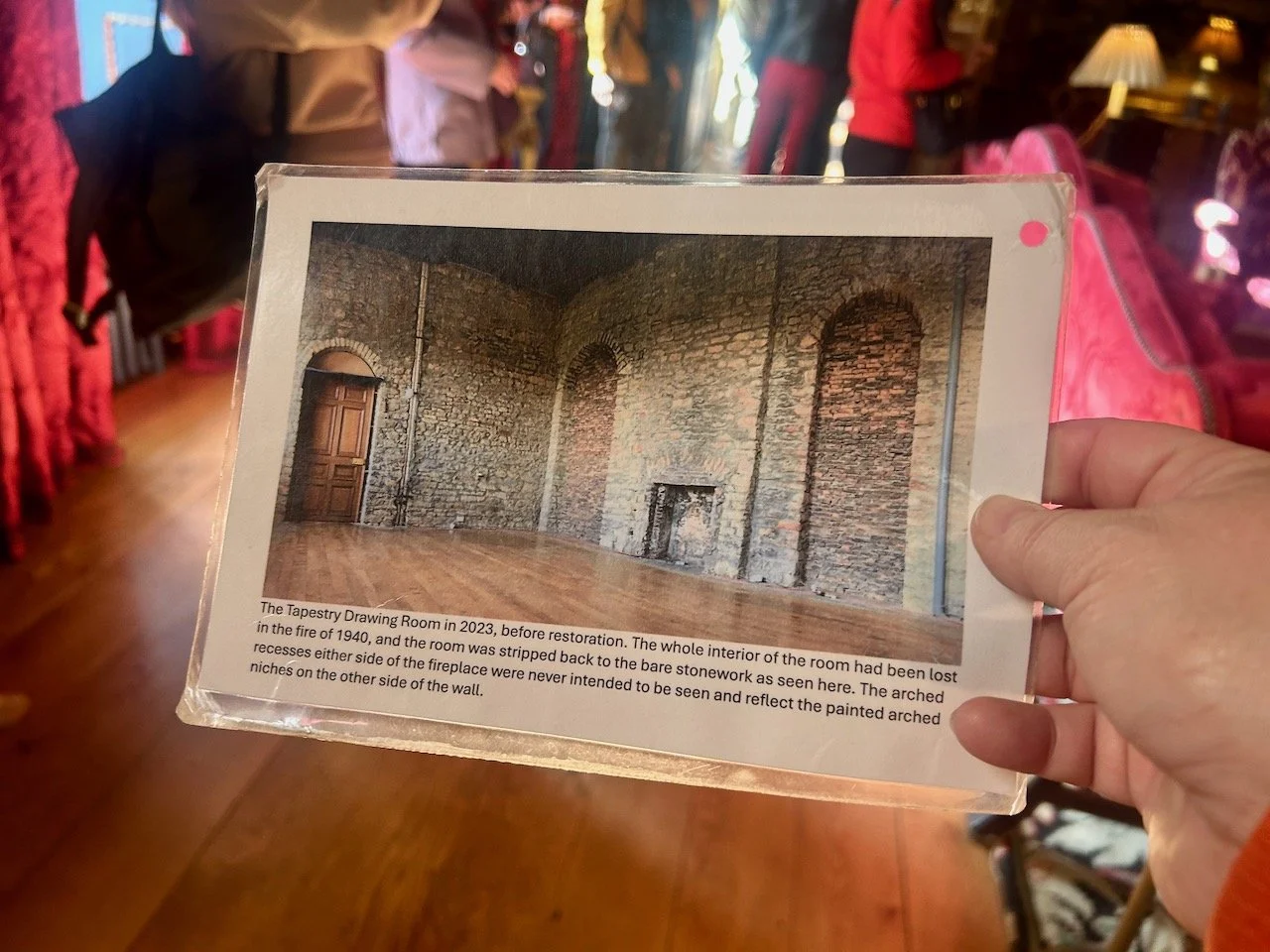
The room is breathtakingly beautiful now, but until recently it remained a shell of its former self destroyed by fire in 1940. The work to rebuild the room began in 2024 and as the blurb says is a ‘sensitive re-imagining’ of the space rather than a ‘slavish recreation’ of it.

It’s hard to believe that such a short time ago it looked like this, isn’t it?

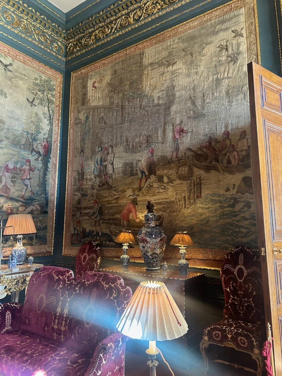
The Four Seasons tapestries

Given that ‘tapestries’ features heavily in the name of the room, you’d expect to see them there, and they were - though luckily at the time of the fire they were hung in another part of the house, which saved them. They’d only been in this room for around 50 years, so they have come full circle with the recent project, bringing them back to the space for which they were originally created.

They were commissioned in 1706 from the London tapestry maker John Vanderbank and show rustic scenes which broadly represent the four seasons.

I’m pretty sure that the first one is Spring, the second is Winter - the river is frozen, the third Autumn - there’s harvesting in the background, and therefore the fourth could be Summer - but I could be convinced either way for the first and the last of these. When you’re passing through the room it’s hard to take all the history in and experience the room too, but the more I look at the tapestries, the more details I see.

SPRING?

WINTER

AUTUMN

SUMMER?

It’s a stunning room, and an amazing transformation and definitely worth a look first hand if you’re that way, and wondering if the ticket price is worth it.

Now if only I could work out which is Spring and which is Summer!

Thisaway or thataway?

Today I’m sharing a more lighthearted look at something that became so important to us as we explored the Gargano Peninsular and quite literally pointed the way ahead as we undertook the routes between our accommodation (our bags were transferred ahead of us) and the circular routes helping us explore our current location.

We became quite adept at spotting them as we walked, and quite often they also lifted your spirits especially towards the end of the walk. No one likes unintended detours, or worse having to retrace your steps, especially when the kilometres have already racked up.

Several of the way markers we so though, did make me smile - like this one, they really didn’t want you to miss it did they?

A tree in the forest marked with two red arrows and a white arrow in between - all pointing right
Another tree marking - top a red dot circled in white, but with the tree markings looks like a fish to me, beneath it is the white/red dash marking, and a large heart carved into the tree's trunk

We were used to following the white and red dash marks on previous walks and holidays we’ve been on, but a few new ones appeared on this trip; the red and white circle above - which wierdly looks like a fish to me, and also some yellow and black markings.

A yellow circle edged in black on a tree trunk, with some illegible stenciled text below in yellow

Often they’d appear together.

The white/red dash on the left and yellow/black circle meet on a tree trunk

And on opposing ‘sides’ of the tree. Which I’m sure made perfect sense as you approached the tree from either direction, but standing alongside the tree just spelled confusion.

A black arrow pointing left, a yellow and black circle and red markings on the left.  on the right of the tree is a red and white inverted L mark and a yellow dash

In the heart of forest they was clearer signage, as you’d expect - no one wants anyone lost in there! It’s also more geared up to day visitors so it made sense, and it was much appreciated as being able to follow the signs without relying heavily on our walking notes was appreciated.

Wooden signposts with place names and distances in the Foresta Umbra

Likewise on the Pilgrim Trail the signage was good, though as this was a move on day we were still checking the walking notes to make sure we didn’t stray off our route unintentionally. Though once we got to the bottom of the valley, with the only way being up we focussed on getting up there rather than the notes!

Another wooden sign on the Pilgrim trail, this one is edge with red and white stripes and a red point for the direction
The Pilgrim trail signs changed slightly but retain their red and white stripes.

On this route we did encounter some ad-hoc gates too, not all of them like this one came with modern conveniences!

Alongside the red/white stripe topped pole is a discarded WC with a homemade metal gate tied to the tree

But it was the yellow and black markings which we followed as we headed up Mount Saraceno as the trip drew to a close, and they didn’t want you missing any turns either.

painted on the side of the rock is a large yellow circle and arrow beneath, both edged in black - the arrow points right
A yellow arrow edged with black pointing up - but is actually ahead, as this one was painted onto the ground

These were hard to miss, but somehow that last walk was the walk where we needed to retrace our steps - thankfully not by much though. All of the markers are much appreciated by many walkers, so this is definitely a post to celebrate the markers and those that maintain them.

Vive the way markers!

Heading across the bay

After a rest day of sorts, we were more ready to tackle the final scheduled walk of our holiday. We knew that one of the paths detailed on our walking notes was closed for urgent repairs, and alternative directions had been provided. These meant that rather than approach Monte Saraceno from the beach, we’d approach from the landward side, which after reading the original notes, which said ‘the ascent was steep (vertiginous in places)’ I think I was pretty glad to be honest.

The amended route would take us up Monte Saraceno which is home to a necropolis with 500 tombs dating back to the ancient Daunia civilisation, and armed with our supplies bought on yesterday’s jaunt into Mattinata we set off, after stopping to take this picture which shows where we were heading.

Looking across the bay, taking standing behind the ivy at our hotel
Leaving our hotel walking down to the coast

After leaving the hotel instead of heading to walk along the pebbly beach (that was another bonus of the changed route!) we headed back towards the road we’d arrived on a couple of days before, and past many more olive trees than we’d seen that day.

Walking past olive groves

There was more to see alongside the olive pruning that kept our interest up.

A green ornate gate in an old brick wall
A fiat car parked under a large olive tree (which is way larger than the car!)

We walked until reaching these roadworks which thankfully weren’t in the direction we were heading, but as we orientated ourselves we worked out this was the route we would be due to take to head into the town of Mattinata later on our walk. But that was for later so on we went admiring the plants and scenery that surrounded us.

road closed signs - and the road looks quite shut
small flowering pink plants growing among the stone wall
Agave type plants growing against a wire fence
Figs growing high above us

By now we were heading up, and already the views were opening up. The headland in the distance is where we’d walked from, and where we would be walking back to later on. I always like to keep that in mind!

Starting to climb Mount Saraceno and looking across to where we started earlier on

The amended walking notes which had been emailed to us before we left were pretty clear, but nonetheless I’m always grateful for clear directional instructions such as this:

A large yellow and black arrow sprayed onto the rock - we'll go that way then

Now we were getting a glimpse of what was ahead of us, and it looked fascinating.

Looking at the views of Mount Saraceno as we headed towards it

And we had a perfect view of the small white town of Mattinata which we’d visited yesterday.

Looking back to the 'white' town of Mattinata

And up we went.

Taking the wrong path skirting the wall amongst dried grass

Until we realised we’d gone wrong following the path pictured above. It could have been right, but it wasn’t, and when we continued to skirt around the wall with no mention of it in the notes we checked again, and then retraced our steps before fairly easily finding the correct path, noticing that this one matched the walking notes more - and for longer.

A much wider gravelled path leading to the headland of Mount Saraceno

Up we went, and down (and across) we looked. Just look at all those olive, and most likely some almond trees, growing in their grid layout.

Looking down across the bay to the winding road beneath and the grid planted olives below

It was idyllic, and we saw very few other walkers, or in fact anyone until we were much closer to our destination.

Trees leaning over the path with the clear blue sea visible at the end of the path
Heading up the grassy path to the headland of Mount Saraceno
An oblong hole in the rocks on the headland

Excavations on Monte Saraceno have identified the remains of a necropolis with over 500 tombs, showing that the area was already inhabited in the C6th BC, by the Dauni population. The deceased were huddled along with the objects dearest to them, and shields and other objects covered the graves of stone slabs, some of which can be found in the town’s Archaeological Civic Musuem.

Doorways and more blending into the stone wall structures

Reaching the top we were unsure quite where we’d arrived if you know what I mean, as the original and more detailed walking notes would have had us arriving from the beach. We explored for a bit, found a nice rock and tucked into our lunch working out our next move.

A lone tree near the edge of the headland

After sitting and enjoying the tranquility for a bit, then weaving our way through the many paths for a much longer bit we decided to retrace our steps and head back. This time with much less reliance on the walking notes, and more reliance on our memories - which generally seemed to work.

A bright pink scabiosa type plant with a black and red winged insect

It always amazes me that by walking the same route in reverse you see so many different things. On this walk I think that was because we weren’t finding the way, and so were more relaxed, which meant there was more capacity to take in our surroundings.

An intricate and large mesh of webs on a pine tree

Arriving back at those roadworks we’d seen earlier, we decided to rebel again and head back to the hotel rather than detour rather the town. We were off home the next day, and wasn’t in need of anything more that the beach bars or the hotel couldn’t provide.

A great week’s walking around the Gargano Peninsular had been completed successfully, and with a crocked ankle too, which at one point I wasn’t sure I’d be saying at the end of the week. I’ve a few more posts pencilled in from this trip sharing more of the flora, and those gnarly olive trees which seemed to grow any which way, so look out for those.